GridVisio's LoS Link Check searches for one possible reflected signal path — off a nearby rooftop, water, or open ground — using the same real LiDAR terrain precision as its standard Fresnel check. It's a desktop planning aid that gives you an extra, honest data point before a site survey, not a model of the multipath signal reconstruction NLoS radios do internally.
GridVisio is coverage-planning software, not an NLoS radio vendor — this isn't a "GridVisio vs. Tarana" comparison, because the two aren't the same kind of product. Tarana (and similar NLoS-capable platforms) reconstruct a usable signal from real multipath reflections in hardware, in real time, in ways no desktop terrain model can predict. GridVisio's NLoS reflection check does something much narrower: it tests one candidate reflection point geometrically against real terrain and reports whether that specific path looks clear. Useful extra context for planning around a Borderline or Obstructed direct link — not a substitute for your radio vendor's own link-budget tools or a real site survey.
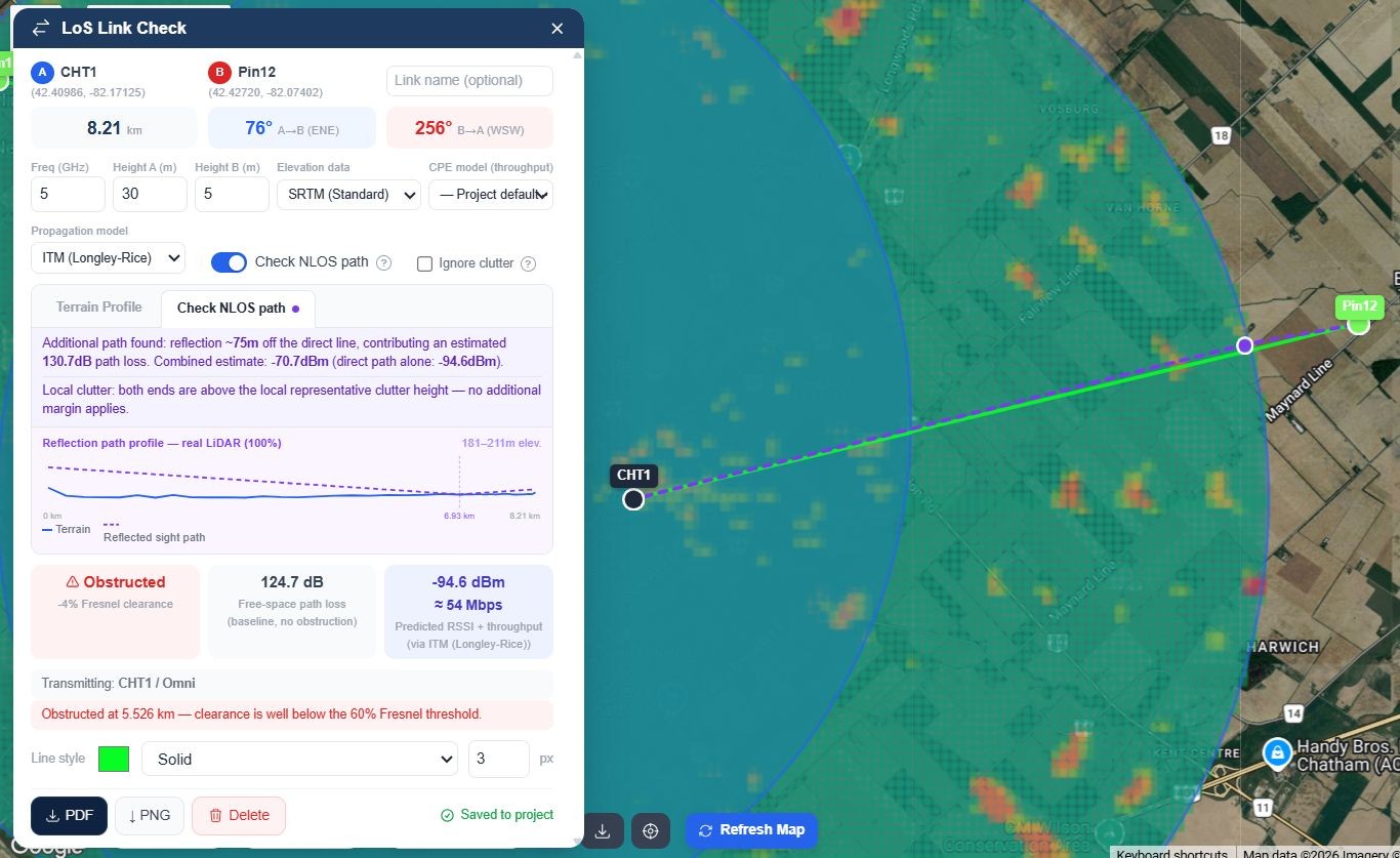
NLoS reflection path result on a Borderline link, with real LiDAR terrain
A geometrically obstructed direct path doesn't automatically mean "no link" for NLoS-capable hardware — but knowing whether a plausible reflected path exists at all is useful before you commit a truck roll or a radio pair to a site.
The search tries a handful of fixed lateral offsets on either side of the direct line and only accepts a candidate when both legs — transmitter to reflection point, and reflection point to receiver — are independently confirmed clear against real terrain. No candidate found, no claim made.
Where free public LiDAR coverage exists — USGS 3DEP in the US, and six other regional government sources (England, Wales, Scotland, Canada, France, Netherlands) — the reflection search uses real measured surface height, not a land-cover category estimate.
When a candidate reflection is found, GridVisio reports its lateral offset, the extra path loss it adds, and a combined RSSI estimate next to the direct-path-only number — power-summed, not phase-accurate, and clearly labeled as such.
Real constructive/destructive interference depends on continuously-varying, sub-wavelength path-length differences that no terrain dataset can predict at any resolution. That's exactly the gap NLoS hardware's own real-time signal processing is built to close — not something GridVisio claims to model.
Three distinct levels of "does this link work," each doing a genuinely different job. GridVisio covers the first two; the third is what NLoS-capable radio hardware exists for.
| Level | What it checks | Who does it |
|---|---|---|
| Tier A — Fresnel clearance | Is the direct line geometrically clear, using real terrain, land-cover, and LiDAR height? Clear / Borderline / Obstructed, with an exact clearance percentage. | GridVisio's standard LoS Link Check, every plan |
| Tier B — reflection path | Does one specific candidate reflected path exist and look clear on both legs? Reflection offset, added loss, and a combined RSSI estimate — power-summed, single-candidate, geometry only. | GridVisio's NLoS reflection path check (Pro/Trial) |
| Real multipath reconstruction | Continuously adapting to real, time-varying multipath in the actual RF environment — the thing that makes an NLoS link genuinely usable in practice, not just theoretically plausible. | The NLoS radio hardware itself (e.g. Tarana), plus a real site survey |
14-day free trial — LoS checker with NLoS reflection path check, real LiDAR terrain, BDC export, and more. No credit card required.
Start free trial