GridVisio is a browser-based coverage planning tool for fixed wireless ISPs. Sector antennas, subscriber import, LoS link check, BDC/BEAD export, and a lead-capture widget — all included in your subscription. Compared to other tools on the market, GridVisio offers no per-export charges, EU/GDPR hosting, and a permanent free tier.
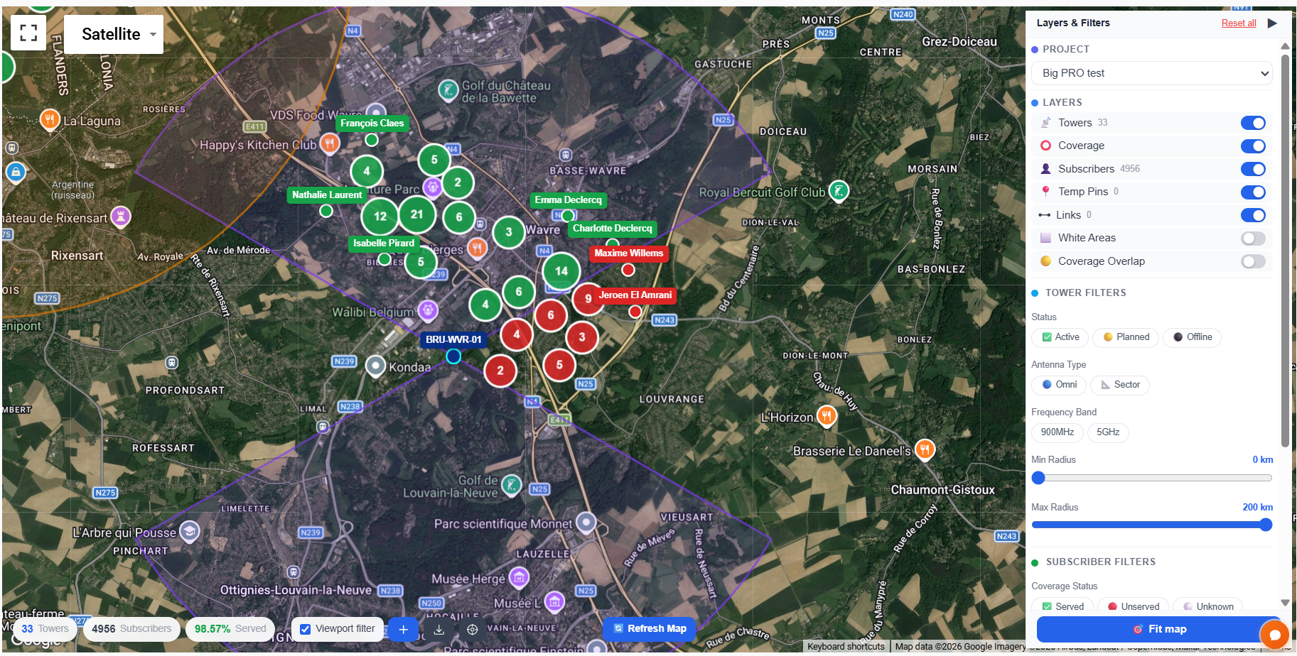
Full coverage map with 33 towers and 4,956 subscribers
What makes GridVisio different
Many WISP coverage tools on the market charge per export, require PayPal, are locked to one hardware vendor, or are hosted outside the EU. GridVisio is designed to avoid all of these.
No per-file export fees
All exports — CSV, XLSX, PDF, PNG, KMZ, BDC, and BEAD — are included in your subscription. No per-file charges, no PayPal order pages, one predictable monthly fee.
EU-hosted · GDPR-native
Your network topology and subscriber data are stored on Hetzner servers in Germany. GDPR compliance is not an afterthought — it is built into the infrastructure.
Hardware-agnostic
Works with Ubiquiti, Cambium, MikroTik, Mimosa, Baicells, or any mix. Unlike vendor-specific tools, GridVisio maps whatever equipment you run.
Lead-capture widget included
The Pro widget converts website visitors into qualified leads with real LoS validation. Push leads to your billing system via webhook or Zapier — no extra charge.
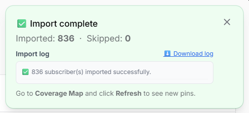
Subscriber tracking built in
Import your subscriber list via CSV or XLSX. Served/unserved status calculates automatically whenever towers change. No address-list add-ons required.
BDC & BEAD export, free
Generate FCC BDC availability files and BEAD grant documentation from your data. Included in Starter and Pro — no per-file charge.
Feature comparison
How GridVisio compares to other coverage tools available for WISPs in 2026.
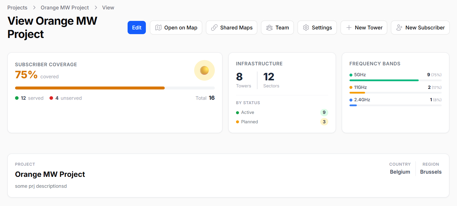
GridVisio project overview
Feature
GridVisio
Typical per-export tools
Export pricing
All exports included in subscription
Per-file charges (KMZ, BDC, address lists)
BDC / Form 477 export
✓ Included in Starter+
Typically charged per file
BEAD grant documentation
✓ Included
Often not available
Data hosting
EU (Hetzner, Germany) · GDPR
Typically US-hosted
Hardware lock-in
None — any vendor
Some tools are vendor-locked
LoS / Fresnel zone check
✓ SRTM / ASTER / USGS elevation
Varies by tool
Subscriber import (CSV/XLSX)
✓ Auto served/unserved
Varies — often paid add-on
Serviceability widget
✓ Pro — LoS-validated lead capture
Some tools offer this
Drive test import & overlay
✓ GPS-timestamped signal tracks
Rarely available
White area detection
✓ DBSCAN spatial clustering
Varies
Free trial
14-day Starter trial, no credit card
Often limited or none
Free tier (permanent)
✓ 1 project / 5 towers / 100 subscribers
Most tools charge from day one
All your exports included
Many coverage tools on the market charge separately for file exports — sometimes routing payments through third-party checkout pages. GridVisio includes every export format in your monthly subscription: CSV, XLSX, PDF, PNG map, KMZ (Google Earth / GIS), FCC BDC availability file, and BEAD grant package.
Generate as many exports as you need. No per-file charge, no external checkout, no surprises at the end of the month.
Subscriber import with auto-classification
Frequently asked questions
Does GridVisio use RF propagation modeling?
GridVisio uses geometric sector modeling — pie-slice polygons defined by azimuth, beamwidth, and radius. For link-path analysis between two points, the LoS / Fresnel zone tool uses real terrain elevation data (SRTM 30m, ASTER 30m, or USGS 10m for the US). This is faster and simpler than full RF propagation, while still giving an accurate picture of intended coverage.
What exports are included in the subscription?
All of them: CSV, XLSX, PDF project report, PNG map (via OpenStreetMap, not Google Maps), KMZ (Google Earth / GIS), FCC BDC availability file, and BEAD grant documentation. Starter plan and above. No per-file fees.
Is GridVisio GDPR-compliant?
Yes. GridVisio is operated by EXODATA SRL (Romania, EU) and hosted on Hetzner servers in Germany. All data is stored within the EU. No subscriber or network data is shared with third parties.
What plan do I need for BDC export?
BDC and BEAD exports are available on Starter ($19/month) and Pro ($39/month). Start with a 14-day free trial — no credit card required.
Can I import my existing coverage data?
Yes. Import tower locations via CSV (lat, lng, and sector parameters). Import subscriber lists via CSV or XLSX. If you have existing data in another tool, export it to CSV and GridVisio can import it.
Start mapping your network today
14-day free trial of all features — no credit card required. Import your towers and subscribers in minutes.