England, Wales, and Scotland aren't the same elevation dataset. GridVisio doesn't pretend they are.
A lot of coverage tools quietly treat "UK" as one elevation source. It isn't — the Environment Agency, Natural Resources Wales, and the Scottish Remote Sensing Portal each publish their own LiDAR independently, on different schedules, in different formats. GridVisio queries whichever one actually covers your link, automatically, and tells you which it used.
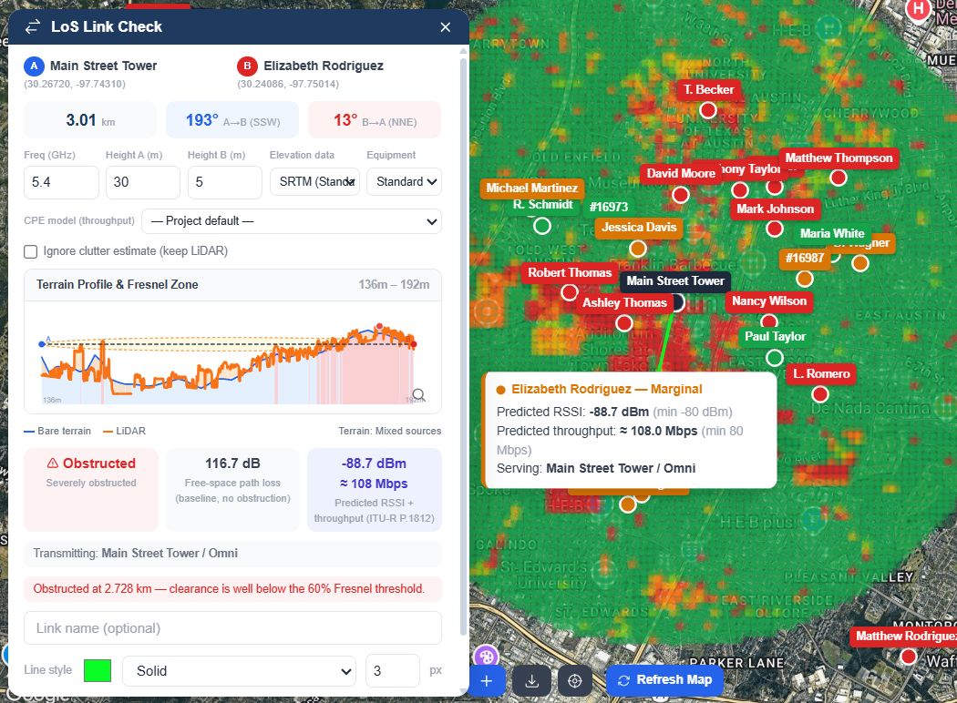
A real link check running on Environment Agency / NRW / SRSP-sourced terrain, not a generic global DEM
Why UK WISPs end up here
England, Wales, and Scotland each got their own integration, not one generic "UK LiDAR" checkbox — because the underlying data genuinely isn't one dataset.
England: ~99% covered by the Environment Agency's own DSM
Near-complete 1m LiDAR from the Environment Agency's composite Digital Surface Model. Pulled in automatically, no toggle — the actual measured rooftop or treetop near your path, not a category guess.
Wales and Scotland, on their own terms
Wales: Natural Resources Wales' single nationwide surface model. Scotland: the Scottish Remote Sensing Portal's ten separate regional survey programmes, still expanding — GridVisio checks every relevant one for your link rather than assuming a single index covers the whole country.
Real backhaul distances
10km link length on Starter, 20km on Pro — enough for a genuine cross-valley or cross-loch hop, not just a last-mile drop. Fresnel clearance, bearing, and FSPL computed identically at any length.
Predicted signal, not just geometry
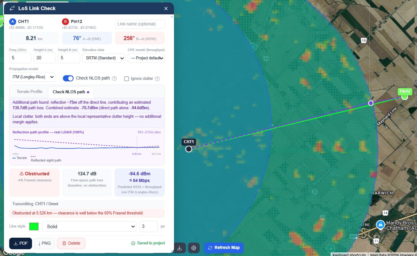
ITU-R P.1812 propagation prediction alongside the Fresnel check, extending to ITM or FSPL+P.526 outside its frequency range — a dBm number and, with a CPE model selected, an estimated Mbps. The same engine drives the RF Heatmap so numbers never contradict each other.
Find where to build next
Import your own subscriber list and GridVisio clusters unserved locations by density (DBSCAN), then estimates reach from a hypothetical tower before you commit to a site visit — whether that's chasing a Project Gigabit contract or just deciding where the next mast goes.
Coverage widget for your own site
Embed an address-check widget on your website. A visitor's address gets a real LoS check against your nearest masts, not a polygon overlap — so the lead you receive already tells you which site would serve them.
A hillside in the Pennines and a loch in the Highlands aren't the same problem
A link crossing a Welsh valley, a mast reaching over a Pennine ridge, a backhaul hop along a Highland glen — a coarse 30m global elevation model quietly gets all three wrong in different ways. Each nation's own 1m LiDAR catches the fold in the ground, the shelterbelt, or the roofline that a smoothed dataset erases.
Where none of the three national sources has reached yet — including, currently, Northern Ireland — GridVisio falls back to SRTM 30m automatically rather than refusing to run, and always states which source produced the result you're looking at.
Fresnel clearance computed against real 1m surface data, not a smoothed approximation
One coverage map, every layer you actually maintain
Towers and sectors, subscribers, saved LoS links, unserved clusters — all on one map, toggleable by layer. Run an RF Heatmap per sector or per site and see predicted signal strength across your whole footprint, using the same propagation model as the link checker.
Export a clean PDF or PNG of any link check for a customer file, an internal record, or a contract or partner application — no extra formatting step, no per-file fee.
RF Heatmap for a sector, driven by the same propagation engine as the LoS checker
Frequently asked questions
Does GridVisio cover all of the UK, including Northern Ireland?
England (~99%, Environment Agency), Wales (Natural Resources Wales' nationwide model), and Scotland (Scottish Remote Sensing Portal, ten regional programmes and still expanding) each have real LiDAR integrations. Northern Ireland does not yet — links there fall back to SRTM 30m automatically rather than failing, and the result always states which source was used.
Why does it matter that England, Wales, and Scotland are separate sources?
Because they genuinely are three different organisations publishing on three different schedules, in three different formats. A tool that assumes one unified "UK LiDAR" index will either miss real coverage or silently mishandle one nation's data. GridVisio queries each one on its own terms and reports which one actually answered.
What's the difference between this and the SRTM data most tools use everywhere?
SRTM is a 30m-resolution global radar dataset — fine for a rough first pass, but it can average away a ridge, a hedgerow, or a roofline that sits inside a single 30m cell. Each national LiDAR source here is 1m resolution, so features that actually intrude on a Fresnel zone show up instead of getting smoothed out.
Can this help with a Project Gigabit contract or BDUK documentation?
GridVisio isn't a filing tool for Project Gigabit, BDUK, or any specific contract process and doesn't generate their paperwork. What it gives you is exportable, defensible link and coverage data — terrain profile, Fresnel clearance, predicted signal strength — as a PDF or PNG you can attach to whatever documentation a given contract requires.
Is pricing in pounds?
Billing is in USD — $19/month Starter, $39/month Pro, both with a 14-day free trial and no credit card required to start. There's also a permanent $0 Free plan with core Starter features included.
Do I need to import my own subscriber and mast data?
Yes — towers, sectors, and subscribers are imported via CSV/XLSX or entered directly on the map. Once they're in, white area detection, reach estimates, and the RF Heatmap all run against your real network, not a sample dataset.
See your own network on real UK terrain
14-day free trial — LoS checker, RF heatmap, white area detection, and more. No credit card required.