✓ WISP Coverage Mapping Alternative

WISP coverage mapping
without the per-file fees

GridVisio gives you sector coverage mapping, subscriber import, LoS link check, BDC/BEAD export, and a lead-capture widget — all in your subscription. No per-export charges. Hardware-agnostic, EU/GDPR-hosted, from $0.

Start 14-day free trial See all features
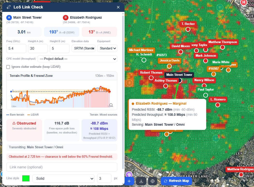
GridVisio LoS Link Check with real USGS 3DEP LiDAR terrain profile, Fresnel zone clearance, and RF propagation heatmap overlay

LoS Link Check with real LiDAR terrain profile, over a live RF propagation heatmap

How GridVisio compares

GridVisio sits in the same category as WISP coverage mapping tools like TowerCoverage and cnHeat, with a comparable feature set at a more accessible starting price. From here on, we compare GridVisio against other coverage mapping apps in general on the features that matter most.

FeatureGridVisioOther apps
Export fees$0 — all exports includedOften a per-file add-on (KMZ, SHP, 477)
Starting priceFree forever + Starter $19/moTypically $25–$349/mo, limited free tier
Data hostingEU · GDPR-native (Hetzner, Germany)Often US-hosted, not always GDPR-native
Hardware lock-inNone — any vendorVaries — some are vendor-locked
Sector coverage mapping✓ Azimuth / beamwidth / radius✓ Varies, often RF propagation modeling
LoS / Fresnel zone check✓ SRTM / ASTER / USGS + real US LiDARVaries by provider
RF propagation heatmap✓ Pro — ITU-R P.1812, LiDAR-awareVaries by provider
Subscriber import (CSV/XLSX)✓ Auto served/unservedOften a paid add-on
BDC / Form 477 export✓ Included in Starter+Often a per-file charge
BEAD grant documentation✓ IncludedNot always available
KMZ export (GIS / Google Earth)✓ Included in Starter+Often a per-file add-on
Serviceability widget✓ Pro — LoS-validated lead captureVaries by provider
Drive test import & overlay✓ GPS-timestamped signal tracksNot commonly offered
White area detection✓ DBSCAN spatial clusteringVaries by provider
Free trial14-day Starter trial, no credit cardOften a limited free tier

Why WISPs switch to GridVisio

The most common reasons operators choose GridVisio over the alternatives.

No per-file fees

Many other apps charge for KMZ, FCC 477/BDC, and address lists. In GridVisio all exports are included — download as many as you need, one predictable monthly fee.

EU-hosted & GDPR-ready

Your subscriber data is stored on Hetzner servers in Germany. GDPR compliance is native — important for European operators and BEAD/EU grant programs.

Lead-capture widget included

The Pro widget converts website visitors into qualified leads with real LoS validation. Push leads to Splynx, UISP, or any CRM via webhook or Zapier — no extra charge.

Subscriber tracking built in

Import your subscriber list via CSV or XLSX. Served/unserved status is calculated automatically. No address-list fees, no add-ons.

BDC & BEAD export, free

Generate FCC BDC availability files and BEAD grant documentation directly from your data. Included in Starter and Pro — no per-file charge.

Hardware-agnostic

Works with Ubiquiti, Cambium, MikroTik, Mimosa, Baicells, or any mix. Unlike some competing tools that are locked to a single hardware vendor — and built-in equipment presets for common Ubiquiti, Cambium, and Mimosa gear auto-fill sector RF parameters in one click.

Real LiDAR terrain, not just bare elevation

LoS Link Check automatically layers real USGS 3DEP LiDAR height where available in the US — actual treetop and rooftop height, not a category estimate. The Pro RF Propagation Heatmap (ITU-R P.1812) uses the same real terrain and land-cover data to predict signal strength across your whole coverage area.

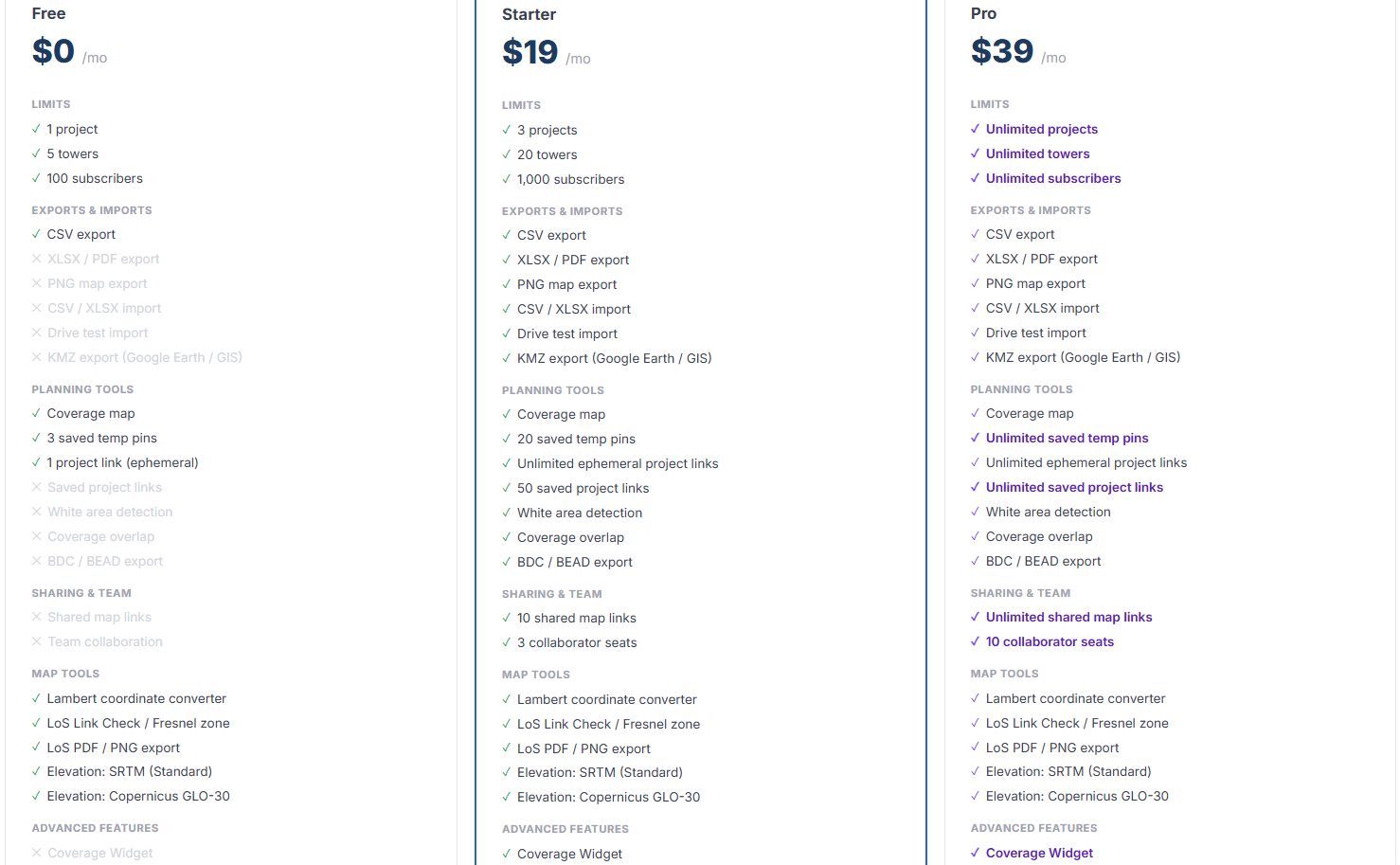
GridVisio pricing — Free, Starter $19/mo, Pro $39/mo. All exports included.

GridVisio pricing — Free, Starter $19/mo, Pro $39/mo. All exports included.

Frequently asked questions

Does GridVisio use RF propagation like other coverage tools?
GridVisio uses geometric sector modeling (pie-slice polygons by azimuth, beamwidth, radius) for the basic coverage shape. For link-path analysis between two specific points, the LoS / Fresnel zone tool uses real terrain elevation data (SRTM, ASTER, or USGS 10m for the US), automatically layered with real USGS 3DEP LiDAR height where available. For area-wide prediction, the Pro RF Propagation Heatmap uses ITU-R P.1812, an internationally standardised point-to-area model, computed from that same real terrain and land-cover data.
Can I migrate my data from another coverage tool to GridVisio?
Yes. Export your tower locations from your current tool as a spreadsheet and import via the tower import feature. Subscriber lists import directly via CSV or XLSX. Contact [email protected] for migration help.
What does "no per-file fees" actually mean?
Many coverage mapping apps charge separately for KMZ / Shapefile / FCC 477 census-block exports, and for marketing address lists. In GridVisio, CSV, XLSX, PDF, PNG, KMZ, BDC, and BEAD exports are all included in your Starter or Pro subscription.
Is the serviceability widget comparable to other coverage-check widgets?
Yes. The Pro widget captures contact details, runs a real LoS analysis to your nearest towers, and delivers a qualified lead to your inbox. Leads push to billing systems via webhook or Zapier. Three configurable modes: coverage-only, coverage-then-lead, or lead-form-first.

Ready to switch?

Start your 14-day free trial — no credit card. Import your towers and subscribers in minutes.

Start free trial